Mineral King, Sequoia National Park
Mineral King is a separate valley, the East Fork of the Kaweah,
which was first developed as
a mining area. This prior development kept the area outside of the early
park boundaries even though it is adjacent to the original Hockett Meadow
area.
Mineral King was added to the park after a series of events that led to
a ski resort proposal that finally alerted people to the potential of
this region and the need to protect it.
Thus there are groups of private cabins and abandoned
concrete dams built to enlarge some of the natural lakes.
The mining was not as extensive (nor as productive) as the
classical gold rush regions of California or
parts of Colorado, but traces will remain for a few more centuries.
The road remains closed
through the winter, but is not as bad as people often describe it, assuming
that you do not mind constant curves, constant up hill, and a minimal two
lanes. Compared to many other Sierra access roads, this one is very good.
The few sections without pavement are smooth and well maintained.
There are several campgrounds and a privately operated "lodge" (Silver
City Resort) so that you
can spend some time in this remote, yet accessible, valley. Most hiking starts
out going UP, but leads to lakes and passes
relatively quickly. Sawtooth (peak and pass) is a good hike. Sawtooth peak is
visible from other parts of the park such as from Alta Peak across the
Kaweah River.
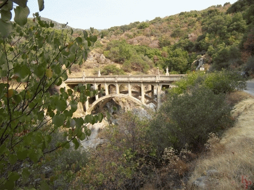 The 1923 bridge on the Mineral King Road. A lot of bridges
built since then are falling apart and never looked as nice. At this point
the road switches to the opposite side of the river, and continues the
climb up to the park boundary. The date of the bridge gives the date of the
road -- 1923. Fortunately, there is not a lot of traffic on the road.
The 1923 bridge on the Mineral King Road. A lot of bridges
built since then are falling apart and never looked as nice. At this point
the road switches to the opposite side of the river, and continues the
climb up to the park boundary. The date of the bridge gives the date of the
road -- 1923. Fortunately, there is not a lot of traffic on the road.
|
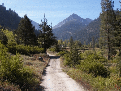 The Mineral King Road continues, mostly paved, but sometimes very good gravel
or dirt, and eventually becomes a trail. The early
part of the trail follows the old mining access road. This was never a
very successful mining area (unlike parts of Colorado, the "Gold Country" of
the Sierra, or parts of Alaska), but signs of the mining remain. Much moreso
than other areas, there are lower slopes without trees due, I assume, to the
use of timber for the mining operations. There are a few Sequoia groves along
the road.
The Mineral King Road continues, mostly paved, but sometimes very good gravel
or dirt, and eventually becomes a trail. The early
part of the trail follows the old mining access road. This was never a
very successful mining area (unlike parts of Colorado, the "Gold Country" of
the Sierra, or parts of Alaska), but signs of the mining remain. Much moreso
than other areas, there are lower slopes without trees due, I assume, to the
use of timber for the mining operations. There are a few Sequoia groves along
the road.
|
 Return to my Sequoia Kings Canyon home page.