
2021-2022: The fires (fall 2021) have made visiting Sequoia difficult (Grant Grove in Kings Canyon is less impacted). The visitor structures and most of Giant Forest survived, but with the December rains, some roads may have problems. Many of the damaged sequoias were in the more remote groves that are not on the usual tourist path. These groves provide an important haven for these magnificent trees.
2020: This is a strange year. COVID closed the park for weeks. The current status is that you can get there and some lodges and campgrounds are available. No Giant Forest shuttles. The backcountry is available for hiking. Smoke from fires south of the park have closed Sequoia in September (Kings Canyon briefly closed).
Another dry winter (2017-2018) for Sequoia and Kings Canyon. This will increase the stress on the trees, but for most visitors will not be noticed.
Sequoia and Kings Canyon National Parks are 2 of the earlier national parks -- Sequoia National Park was established (encompassing the southwestern area of the park around Hockett Meadow) about a week before Yosemite and General Grant were created. At that time, the Giant Forest was added to Sequoia National Park. Later, the Kern drainage, with no Sequoias, was added to Sequoia National Park, and the Kings drainage (also with no Sequoias) was added to General Grant (then a small area around the General Grant tree) and the name changed to Kings Canyon National Park, which is now in two separate pieces. While Sequoia and Kings Canyon are separate parks, they are managed as a single unit. The possible winter closure (first major snow to April 1) of the Generals' Highway between the parks makes them completely separate part of the year. (In 2013 the wording is different so the road may be open, or not.)
The Giant Sequoia National Monument was established in April 2000 to preserve a number of Sequoia groves that lie outside the 2 adjacent parks. Tnis Monument includes much of the area between Grant Grove and the rest of Kings Canyon (except those areas in Monarch and Jennie Lakes Wildneress areas) plus a southern section roughly around the Johnsondale road. With the Monument, the 2 parks, and the forest service wilderness areas, much of the southern Sierra is now provided some level of protection, though such protection is never complete, permanent or final. Included in this area is the Boole Tree, at one time thought to be the largest, but it only ranks #6 (or #8, both rankings are given on the Boole Tree page), or #7 on the Sequoia NP listing (how do you really get the volume of the tree and with annual growth about the same as the listed difference in size, can you really distinguish between 6, 7, and 8?)
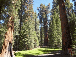
Even though it is not the largest identifiable grove of Sequoias, Giant Forest is the most accessible large grove. Highlights include Crescent Meadow, the General Sherman tree, the Congress Trail, the site of the Giant Forest cabins (replaced by Wuksachi Village, a more expensive, better insulated and less environmentally harmful accomodation), and (almost) Moro Rock. For the winter of 2011-12, the road between Giant Forest and Grant Grove was not plowed and was mostly closed. Since the winter of 2012-13, the wording is different: "the road may be closed for weeks." Construction on the Ash Fork to Giant Forest road is done for a while.
The original section of what is now Kings Canyon National Park, Grant Grove is ecologically more a part of Sequoia than Kings Canyon. This area has several campgrounds (one open all year), a variety of lodging options, the visitor center, the General Grant tree, and Wilsonia (a private in-holding). There are more accomodations here than in Sequoia and the drive is easier.
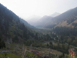
The Lower Kings Canyon has the V shape of an eroded valley rather than the U shape of a glacial valley. Roads End (with lodge and trail heads) is only a little lower than Yosemite Valley, but is much warmer (it is about 100 miles South of Yosemite). There is less water since rain and snow generally decrease as you go south along the Sierra. Access is limited in winter because the road is closed.
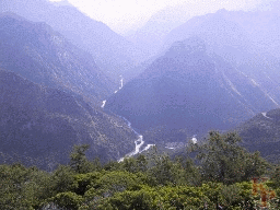
Some references call this the deepest canyon in some subset of the world (with the depth measured somewhere in the vacinity of this picture). There is no really obvious flat top for the canyon (as is the case of the Grand Canyon), and however deep it is not an easy hike up. The view is primarily up the Middle Fork (which leads to Muir Pass and Palisade Creek but the road is up the South Fork (to the right). Access to the North Fork is via other routes (e.g. Courtwright Reservoir). These trips are far more interesting than the lower Middle Fork, and the trails that leave the hot, dusty, low end of the road at Cedar Grove.
Mineral King is a separate valley originally developed as a mining area. This development kept the area outside of the early park boundaries (it is adjacent to the inital section of the park around Hockett Meadow). Mineral King was added after a ski resort proposal that served to alert people to the potential of this region and the need to protect it. The mining was not as extensive as the California gold country or parts of Colorado, but traces (cabins, dams, mine shafts) will remain for a few more centuries. Private cabins and other structures remain from the time before the Park Service took over management. The road closes through the winter, but is not as bad as often described. It is constant curves, constant up hill, and a minimal width for two lanes. But, compared to many other Sierra access roads, this one is very good.
Silver City Resort and several campgrounds provide accomodations. Most hiking starts out going UP, but leads to lakes and passes relatively quickly. Sawtooth (peak and pass) is a good hike. Sawtooth peak is visible from other parts of the park such as from Alta Peak across the Kaweah River.
Most of Sequoia and Kings Canyon is managed as Wilderness (essentially everything more than 1 mile from a road -- wilderness is best defined by what the Wilderness Act of 1964 says, not by anything else). The Wilderness has far fewer people. You have to walk to see it.
The Sequoia backcountry is dominated by the almost straight North-South Kern Trench, with plateaus on either side leading to peaks (especially Mt. Whitney.) In addition to the river, there are numerous high lakes and basins leading down to the Kern and (west of the divide) Kaweah Rivers. The only way to appreciate this area is to visit more than once. Each trip will be different, with different weather and different snow, but the beauty is constant. Access is either from the park roads, or from the east via the Mt. Whitney (14494ft, 4417m) or Shepard Pass (12050ft) trails -- neither easy. There is also a trail from the south along the Kern River.
The divide between the Kings and Kern Rivers includes Forrester Pass (13,160ft, the highest point on the Pacific Crest Trail). Going south, be sure to make the turn at the top or bring your parachute. Kings Canyon wilderness has numerous basins, lakes passes, side trips, and alternate trails to the east (Sawmill, Baxter, Taboose, or Kearsarge) or from the north via SCE or PGE lakes (Courtright, Edison, Florence). At least these are outside the park, unlike Hetch Hetchy where San Francisco continues its destruction of Yosemite. The Rae Lakes region is separate to reduce file sizes.
Evolution Basin (although a part of Kings Canyon NP, it is an upper basin of the San Joaquin River) was described to me as the most beautiful place in the world. I will not argue. Thus it gets a separate page.
Of course you want to visit these parks. They are open summer and winter (though access to the low elevation Kings Canyon closes in the winter) with different activities for each season. Expect snow (and be prepared to drive in snow) in the winter and spring. Starting in 2012, the road between Giant Forest and Grant Grove will close through the winter (saving the costs of partol and clearing snow and rocks).
Are redwoods and sequoias the same? (Not even close.)
How do you tell them apart?
(Other than location.)
The Online Book, The Challenge of the Big Trees gives a detailed history of the establishment of the two parks with their growth and development up until 1990.
The Official Sequoia and Kings Canyon National Parks site has all the offical information, including the pointers to accomodations, camping, hiking, news, traffic, weather, shuttles, etc. Why look anywhere else when this is the current information. See the park newspaper before you get there to plan your visit.
The documentary Ken Burns: National Parks - America's Best Idea is a must-see. Sequoia and Kings Canyon are part of the early discussion.
Maintained by Keith Price.